
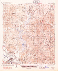
1936 Map of Colfax
USGS Topo · Published 1936About this map
The Red River floodplain and the sprawling waters of Lake Iatt dominate this mid-1930s survey of central Louisiana. The parish seat at Colfax is shown in detail, positioned along the Louisiana and Arkansas Railway and State Highway No 71. This era reveals a landscape transitioning from heavy timbering to managed conservation within the Kisatchie National Forest.
Find a feature on this map
75 named features on this map. Tap any name to fly to it.
Don’t see what you’re looking for? This feature index may not catch every label — zoom into the map to look around manually.
Map Details
Editions of this 1936 Colfax Map
2 editions found
Other maps of this area

1932 · Colfax NE
USGS Topo · 1:31,680

1932 · Boyce NE
USGS Topo · 1:31,680

1932 · Colfax SW
USGS Topo · 1:31,680

1932 · Colfax SE
USGS Topo · 1:31,680

1932 · Colfax NW
USGS Topo · 1:31,680

1935 · Verda
USGS Topo · 1:31,680

1936 · Pollock
USGS Topo · 1:62,500

1937 · Chopin NE
USGS Topo · 1:31,680

1937 · Aloha
USGS Topo · 1:31,680

1937 · Montgomery
USGS Topo · 1:62,500