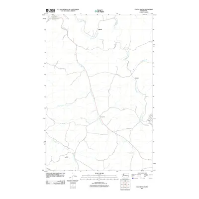
2011 Map of Colfax South
USGS Topo · Published 2011About this map
Albion and the surrounding agricultural landscapes of Whitman County are defined by the winding course of the South Fork Palouse River and its numerous tributaries. This survey captures the rural character of the region, where small settlements like Risbeck, Shawnee, and Parvin are linked by a network of country roads including Shawnee Parvin Rd and Albion Rd. The terrain is marked by seasonal drainages such as Spring Flat Creek and Rebel Flat Creek, which carve through the plateau. For those researching local heritage, the map identifies several family-named landmarks and historic burial sites, including Guy Cemetery near Albion and Davis Cemetery to the southwest. The presence of Spring Flat and names like Hamilton Hill Rd and Prune Orchard Rd illustrate the area's long-standing connection to farming and orchard cultivation in this corner of the Palouse.
Find a feature on this map
40 named features on this map. Tap any name to fly to it.
Don’t see what you’re looking for? This feature index may not catch every label — zoom into the map to look around manually.
Map Details
Editions of this 2011 Colfax South Map
This is the sole edition of this map. No revisions or reprints were ever made.
Other maps of this area

1910 · Pullman
USGS Topo · 1:125,000

1955 · Pullman
USGS Topo · 1:250,000

1958 · Pullman
USGS Topo · 1:250,000

1964 · Diamond
USGS Topo · 1:24,000

1964 · Elberton
USGS Topo · 1:24,000

1964 · Colfax North
USGS Topo · 1:24,000

1964 · Wilcox
USGS Topo · 1:24,000
1964 · Albion
USGS Topo · 1:24,000

1964 · Colfax South
USGS Topo · 1:24,000

1964 · Ewartsville
USGS Topo · 1:24,000