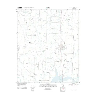
2013 Map of Collinsville
USGS Topo · Published 2013About this map
Collinsville stands as the primary hub in this portion of Grayson County, where residential streets meet the industrial footprint of the surrounding Texas landscape. The area is heavily defined by its energy production history, evidenced by numerous active extraction sites such as the Woodbine Oil Field, Timber Creek Oil Field, and the Collinsville Oil Field. These fields are interspersed with local heritage sites, particularly a high density of family and community burial grounds including Morris Cem, Tuck Cem, and Mt Zion Cem. To the south, the terrain descends toward the northern reaches of Lake Ray Roberts, while the settlement of Shady Grove and the humorously named Sudden Stop Airport mark the rural expanses. The map's network of county roads and creek drainages like Timber Cr and Jordan Cr illustrates the intersection of agriculture, petroleum, and recreation in the early 21st century.
Find a feature on this map
113 named features on this map. Tap any name to fly to it.
Don’t see what you’re looking for? This feature index may not catch every label — zoom into the map to look around manually.
Map Details
Editions of this 2013 Collinsville Map
This is the sole edition of this map. No revisions or reprints were ever made.
Other maps of this area

1901 · Denison
USGS Topo · 1:125,000

1902 · Gainesville
USGS Topo · 1:125,000

1943 · Gainesville
USGS Topo · 1:125,000

1954 · Sherman
USGS Topo · 1:250,000

1958 · Whitesboro
USGS Topo · 1:62,500

1958 · Sherman
USGS Topo · 1:250,000

1960 · Callisburg
USGS Topo · 1:24,000

1960 · Woodbine
USGS Topo · 1:24,000

1961 · Pilot Point
USGS Topo · 1:24,000
1961 · Marilee
USGS Topo · 1:24,000