
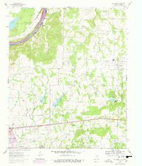
1960 Map of Callisburg
USGS Topo · Published 1963About this map
The Red River carves a wide, looping path along the northern boundary of this Texas-Oklahoma borderland, defining the transition from the sandy flats of Washington to the rolling petroleum-rich hills of Cooke County. At the dawn of the 1960s, the local economy is visibly driven by the Walnut Bend Oil Field and Woodbine Oil Field, where numerous oil and gas wells dot the landscape between Hickory Creek and Timber Creek. Community life centers on the established town of Callisburg and smaller settlements like Custer City, supported by a network of rural institutions including Tabernacle Ch, Spring Grove Ch, and the Gainesville State School For Girls. Genealogists will find significant value in the documentation of numerous burial grounds, such as Center Hill Cem and Nelson Grove Cem, while the inclusion of the Drive-in Theater near Gainesville provides a glimpse into the era's mid-century roadside culture.
Find a feature on this map
38 named features on this map. Tap any name to fly to it.
Don’t see what you’re looking for? This feature index may not catch every label — zoom into the map to look around manually.
Map Details
Editions of this 1960 Callisburg Map
2 editions found
Other maps of this area

1901 · Denison
USGS Topo · 1:125,000

1902 · Gainesville
USGS Topo · 1:125,000

1943 · Gainesville
USGS Topo · 1:125,000

1954 · Sherman
USGS Topo · 1:250,000

1958 · Gordonville
USGS Topo · 1:62,500

1958 · Whitesboro
USGS Topo · 1:62,500

1958 · Sherman
USGS Topo · 1:250,000

1960 · Gainesville South
USGS Topo · 1:24,000

1960 · Gainesville North
USGS Topo · 1:24,000

1960 · Woodbine
USGS Topo · 1:24,000