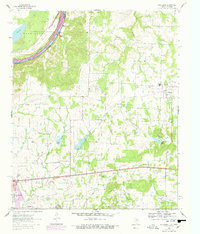
1960 Map of Callisburg
USGS Topo · Published 1978About this map
Lake Texoma and the Red River define the northern boundary of this Texas-Oklahoma borderlands area, where the landscape transitions from the river valley into the upland oil fields. The energy economy of the late mid-century is prominently displayed through the Walnut Bend Oil Field and Woodbine Oil Field, which are marked by numerous oil wells and pipeline networks. Rural life is anchored by small settlements and community landmarks such as Custer City and Callisburg. Genealogists will find significant value in the distribution of local churches and burial grounds, including Union Hill Ch, Spring Grove Ch, and Nelson Grove Cem. Notable institutional presence is seen at the Gainesville State School For Girls on the outskirts of Gainesville, while physical geography is marked by several winding tributaries like Wheeler Creek and Timber Creek feeding into the Red River system.
Find a feature on this map
33 named features on this map. Tap any name to fly to it.
Don’t see what you’re looking for? This feature index may not catch every label — zoom into the map to look around manually.
Map Details
Editions of this 1960 Callisburg Map
2 editions found
Other maps of this area

1901 · Denison
USGS Topo · 1:125,000

1902 · Gainesville
USGS Topo · 1:125,000

1943 · Gainesville
USGS Topo · 1:125,000

1954 · Sherman
USGS Topo · 1:250,000

1958 · Gordonville
USGS Topo · 1:62,500

1958 · Whitesboro
USGS Topo · 1:62,500

1958 · Sherman
USGS Topo · 1:250,000

1960 · Callisburg
USGS Topo · 1:24,000

1960 · Gainesville South
USGS Topo · 1:24,000

1960 · Gainesville North
USGS Topo · 1:24,000