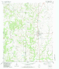
1982 Map of Collinsville
USGS Topo · Published 1983About this map
Collinsville anchors this North Texas landscape, sitting at the junction of the Missouri Pacific railroad and local county thoroughfares. The 1980s terrain is heavily defined by energy extraction, with extensive activity across the Collinsville Oil Field and South Dove Oil Field. The eastern portion of the map showcases the drainage patterns of Jordan Creek and Hog Creek as they move through the rolling prairie toward the Isle du Bois Creek bottomlands.
Find a feature on this map
38 named features on this map. Tap any name to fly to it.
Don’t see what you’re looking for? This feature index may not catch every label — zoom into the map to look around manually.
Map Details
Editions of this 1982 Collinsville Map
This is the sole edition of this map. No revisions or reprints were ever made.
Other maps of this area

1901 · Denison
USGS Topo · 1:125,000

1902 · Gainesville
USGS Topo · 1:125,000

1943 · Gainesville
USGS Topo · 1:125,000

1954 · Sherman
USGS Topo · 1:250,000

1958 · Whitesboro
USGS Topo · 1:62,500

1958 · Sherman
USGS Topo · 1:250,000

1960 · Callisburg
USGS Topo · 1:24,000

1960 · Woodbine
USGS Topo · 1:24,000

1961 · Pilot Point
USGS Topo · 1:24,000
1961 · Marilee
USGS Topo · 1:24,000