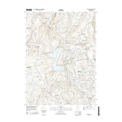
2015 Map of Collinsville
USGS Topo · Published 2015About this map
The Farmington River carves a central path through this Connecticut landscape, anchoring the historic industrial and residential cores of Collinsville and Unionville. This 2015 update illustrates how the valley's steep topography, defined by landmarks like Rattlesnake Hill and Sweetheart Mtn, has historically funneled development along the water and the primary corridors of Albany Tpke and Litchfield Tpke. The vast Nepaug Reservoir dominates the center of the sheet, surrounded by protected terrain and the Huckleberry Hills Trails. Local history is deeply embedded in the rural and suburban fabric through established settlements like Canton Center and Puddle Town, as well as numerous sites of genealogical interest. These include Saint Patricks Cem, Hillside Cem, and Greenwood Cem, along with the suggestive Schoolhouse Hill near Burlington. The map traces a mix of preserved open space and residential growth near Silvermine Acres and Cherry Park.
Find a feature on this map
81 named features on this map. Tap any name to fly to it.
Don’t see what you’re looking for? This feature index may not catch every label — zoom into the map to look around manually.
Map Details
Editions of this 2015 Collinsville Map
This is the sole edition of this map. No revisions or reprints were ever made.
Other maps of this area

1892 · Winsted
USGS Topo · 1:62,500

1892 · Meriden
USGS Topo · 1:62,500

1892 · Granby
USGS Topo · 1:62,500

1893 · Waterbury
USGS Topo · 1:62,500

1893 · Meriden
USGS Topo · 1:62,500

1904 · Waterbury
USGS Topo · 1:62,500

1904 · Litchfield
USGS Topo · 1:125,000

1906 · Farmington
USGS Topo · 1:125,000
1946 · New Britain
USGS Topo · 1:31,680

1946 · Bristol
USGS Topo · 1:31,680