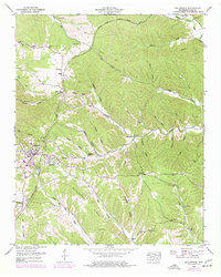
1951 Map of Collinwood
USGS Topo · Published 1977About this map
The Natchez Trace Parkway carves a sweeping arc across this Tennessee landscape, reflecting a mid-century moment where modern infrastructure met long-established rural settlements. In the western portion of the map, the town of Collinwood serves as the primary hub, showing a detailed grid of streets, a High School, and a substation. The surrounding terrain is characterized by a dense network of hollows and ridges, such as the prominent Bucksnort Ridge, which is flanked by the Bucksnort Cem and the waters of Butler Creek. Local family history is deeply rooted here, evidenced by several small burial grounds including Risner Cem, McCall Cem, and Copeland Cem. The transition from earlier decades is visible in the placement of the McCall Sch and Millrock Church, which anchor small communities like Highland and Woodlawn against the heavily dissected topography of the Western Highland Rim.
Find a feature on this map
61 named features on this map. Tap any name to fly to it.
Don’t see what you’re looking for? This feature index may not catch every label — zoom into the map to look around manually.
Map Details
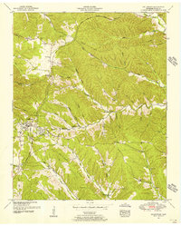
Editions of this 1951 Collinwood Map
2 editions found
Other maps of this area

1905 · Waynesboro
USGS Topo · 1:125,000

1936 · Westpoint
USGS Topo · 1:24,000

1936 · Collinwood
USGS Topo · 1:24,000

1936 · Light
USGS Topo · 1:24,000

1936 · Negro Hollow
USGS Topo · 1:24,000

1936 · Cypress Inn
USGS Topo · 1:24,000

1936 · Three Churches
USGS Topo · 1:24,000
1936 · St. Joseph
USGS Topo · 1:24,000

1936 · Waynesboro
USGS Topo · 1:24,000

1936 · Ovilla
USGS Topo · 1:24,000