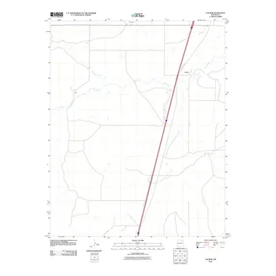
2010 Map of Colmor
USGS Topo · Published 2010About this map
Ocate Creek meanders across the high plains of Colfax County, defining the drainage patterns of this sparsely populated agricultural landscape. The settlement of Colmor serves as a primary point of reference, situated alongside the historic corridor of Old US Hwy 85 which cuts a nearly straight diagonal path through the quadrangle. This 2010 survey illustrates the persistence of small rural outposts like Maes and Montoya in an era of consolidation. The map traces the intersection of Sweetwater Creek and Ocate Creek, revealing how water sources and transportation routes dictated the layout of ranching roads such as C 72 and C 4. This document captures the quiet, open character of Northern New Mexico's ranch lands at the beginning of the 21st century.
Find a feature on this map
10 named features on this map. Tap any name to fly to it.
Don’t see what you’re looking for? This feature index may not catch every label — zoom into the map to look around manually.
Map Details
Editions of this 2010 Colmor Map
This is the sole edition of this map. No revisions or reprints were ever made.
Other maps of this area

1954 · Raton
USGS Topo · 1:250,000

1956 · Miami
USGS Topo · 1:62,500

1958 · Raton
USGS Topo · 1:250,000

1964 · Stony Lake
USGS Topo · 1:24,000

1964 · Wagon Mound
USGS Topo · 1:24,000

1964 · Alto De Hormiga
USGS Topo · 1:24,000

1964 · Colmor
USGS Topo · 1:24,000

1964 · Pinon Hills
USGS Topo · 1:24,000

1965 · Springer
USGS Topo · 1:24,000
1966 · La Chata Crater
USGS Topo · 1:24,000