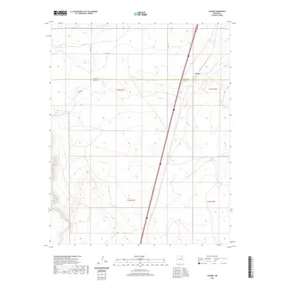
2020 Map of Colmor
USGS Topo · Published 2020About this map
Colmor sits as a lonely sentinel at the boundary of Colfax and Mora counties, where the high plains meet the intricate drainages of the Ocate Cr and Sweetwater Cr. This remote landscape is defined by its water management and transportation corridors, most notably the Charette Lake Canal which cuts across the northern reaches of the quadrangle. The map captures a moment in the modern era where rural infrastructure like Co Rd C-72 and Colmor Rd provide the primary access to the vast ranchlands and township sections. The survey work by the U.S. Geological Survey clearly delineates the Colfax and Mora county line, illustrating how political boundaries often follow arbitrary paths across a natural landscape shaped by seasonal creek beds and arroyos.
Find a feature on this map
13 named features on this map. Tap any name to fly to it.
Don’t see what you’re looking for? This feature index may not catch every label — zoom into the map to look around manually.
Map Details
Editions of this 2020 Colmor Map
This is the sole edition of this map. No revisions or reprints were ever made.
Other maps of this area

1954 · Raton
USGS Topo · 1:250,000

1956 · Miami
USGS Topo · 1:62,500

1958 · Raton
USGS Topo · 1:250,000

1964 · Stony Lake
USGS Topo · 1:24,000

1964 · Wagon Mound
USGS Topo · 1:24,000

1964 · Alto De Hormiga
USGS Topo · 1:24,000

1964 · Colmor
USGS Topo · 1:24,000

1964 · Pinon Hills
USGS Topo · 1:24,000

1965 · Springer
USGS Topo · 1:24,000
1966 · La Chata Crater
USGS Topo · 1:24,000