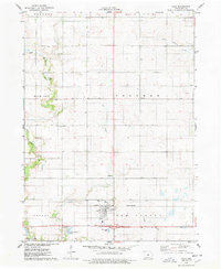
1975 Map of Colo
USGS Topo · Published 1978About this map
Colo sits at the nexus of the Chicago and North Western railroad and several vital prairie waterways in central Iowa. This mid-1970s survey illustrates a landscape defined by organized township boundaries, including Richland, Sherman, and New Albany. The drainage patterns of East Indian Creek and South Minerva Creek carve through the agricultural grid, revealing the natural topography that shaped early settlement. Notable local landmarks for genealogists and historians include several burial grounds such as Oak Hill Cem, Murphy Cem, and St James Cem. Further south, the map documents the Campground and Twin Anchors Lake, providing a clear record of land use and community infrastructure during this era.
Find a feature on this map
25 named features on this map. Tap any name to fly to it.
Don’t see what you’re looking for? This feature index may not catch every label — zoom into the map to look around manually.
Map Details
Editions of this 1975 Colo Map
This is the sole edition of this map. No revisions or reprints were ever made.
Other maps of this area

1954 · Waterloo
USGS Topo · 1:250,000

1954 · Des Moines
USGS Topo · 1:250,000

1955 · Waterloo
USGS Topo · 1:250,000

1956 · Des Moines
USGS Topo · 1:250,000

1957 · Des Moines
USGS Topo · 1:250,000

1969 · Des Moines
USGS Topo · 1:250,000

1975 · Nevada
USGS Topo · 1:24,000

1975 · State Center NW
USGS Topo · 1:24,000

1975 · State Center
USGS Topo · 1:24,000

1975 · Rhodes
USGS Topo · 1:24,000