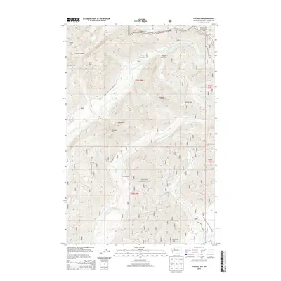
2014 Map of Colonel Bob
USGS Topo · Published 2014About this map
Colonel Bob and the high ridges of the Olympic Mountains dominate this portion of the Olympic National Forest and Olympic National Park. The drainage basins of the W Fork Humptulips River and E Fork Humptulips River define the local topography, carving deep valleys between named heights like Gibson Peak and Stovepipe Mtn. This landscape is characterized by its network of forest development roads, including Natl Forest Develop Road 2204 RD, which provide access to backcountry landmarks such as Campbell Shelter and East Fork Shelter. The map documents the intricate creek systems feeding the larger rivers, with Petes Cr and Gibson Cr navigating the steep descent from Quinault Ridge toward the lowlands. Near the southern boundary, Fitzgerald Peak stands as a prominent marker above the headwaters of Big Cr.
Find a feature on this map
35 named features on this map. Tap any name to fly to it.
Don’t see what you’re looking for? This feature index may not catch every label — zoom into the map to look around manually.
Map Details
Editions of this 2014 Colonel Bob Map
This is the sole edition of this map. No revisions or reprints were ever made.
Other maps of this area

1921 · Quinault Lake
USGS Topo · 1:62,500

1921 · Satsop
USGS Topo · 1:62,500

1947 · Mt Christie
USGS Topo · 1:62,500

1950 · Mt Christie
USGS Topo · 1:62,500

1955 · Grisdale
USGS Topo · 1:62,500

1955 · Quinault Lake
USGS Topo · 1:62,500

1956 · Kloochman Rock
USGS Topo · 1:62,500

1958 · Seattle
USGS Topo · 1:250,000

1962 · Seattle
USGS Topo · 1:250,000
1988 · Shelton
USGS Topo · 1:100,000