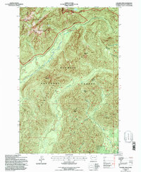
1995 Map of Colonel Bob
USGS Topo · Published 1997About this map
Colonel Bob stands as the literal and figurative high point of this terrain, anchoring the Colonel Bob Wilderness where the drainage systems of the Humptulips River begin their descent. This 1990s revision by the Forest Service illustrates a landscape defined by protected boundaries and high-elevation landforms, including Gibson Peak and Moonlight Dome. The complex network of the Humptulips system is visible in detail, showing the West Fork Humptulips River, the Middle Fork Humptulips River, and the East Fork Humptulips River as they carve through the Olympic National Forest.
Find a feature on this map
30 named features on this map. Tap any name to fly to it.
Don’t see what you’re looking for? This feature index may not catch every label — zoom into the map to look around manually.
Map Details
Editions of this 1995 Colonel Bob Map
This is the sole edition of this map. No revisions or reprints were ever made.
Other maps of this area

1921 · Quinault Lake
USGS Topo · 1:62,500

1921 · Satsop
USGS Topo · 1:62,500

1947 · Mt Christie
USGS Topo · 1:62,500

1950 · Mt Christie
USGS Topo · 1:62,500

1955 · Grisdale
USGS Topo · 1:62,500

1955 · Quinault Lake
USGS Topo · 1:62,500

1956 · Kloochman Rock
USGS Topo · 1:62,500

1958 · Seattle
USGS Topo · 1:250,000

1962 · Seattle
USGS Topo · 1:250,000
1988 · Shelton
USGS Topo · 1:100,000