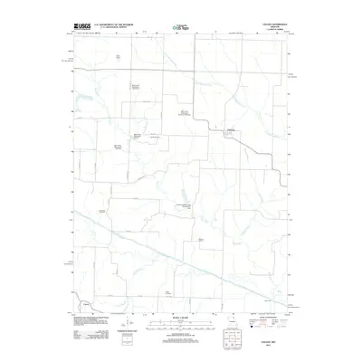
2012 Map of Colony
USGS Topo · Published 2012About this map
Colony and Fairmont anchor this rural landscape in Knox County, where the topography is defined by the winding paths of the Little Wyaconda River and the North Fabius River. The area is characterized by a sophisticated water management network, evidenced by numerous infrastructure projects including the Bear Creek Watershed Structure F-20 Dam and several other dams along Bear Creek. These structures reflect a concerted effort to manage the drainage basins of northeast Missouri, protecting the surrounding agricultural lands from the seasonal volatility of the river systems.
Find a feature on this map
37 named features on this map. Tap any name to fly to it.
Don’t see what you’re looking for? This feature index may not catch every label — zoom into the map to look around manually.
Map Details
Editions of this 2012 Colony Map
This is the sole edition of this map. No revisions or reprints were ever made.
Other maps of this area

1903 · Kahoka
USGS Topo · 1:125,000

1903 · Edina
USGS Topo · 1:125,000

1950 · Neeper
USGS Topo · 1:24,000

1950 · Williamstown
USGS Topo · 1:24,000

1950 · Medill
USGS Topo · 1:24,000

1950 · Colony
USGS Topo · 1:24,000

1951 · Colony
USGS Topo · 1:24,000

1951 · Neeper
USGS Topo · 1:24,000

1951 · Medill
USGS Topo · 1:24,000
1951 · Williamstown
USGS Topo · 1:24,000