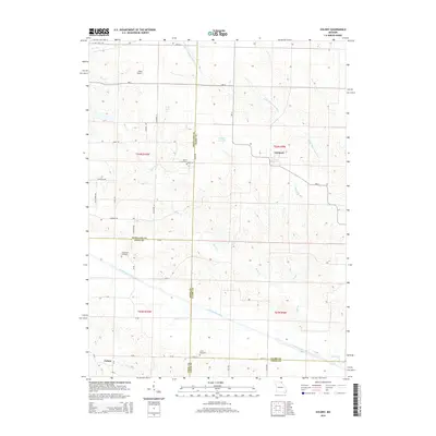
2014 Map of Colony
USGS Topo · Published 2014About this map
Fairmont and the smaller settlement of Colony anchor this modern survey of the tri-county borderlands where Knox, Scotland, and Clark counties meet. The landscape is defined by the drainage systems of the North Fabius River and the Little Wyaconda River, with numerous small tributaries like Bear Cr and Vernon Br carving through the agricultural terrain. Significant genealogical markers are scattered across the rural townships, including Sutter Cemetery near the Clark County line and Standiford Cemetery to the southwest.
Find a feature on this map
46 named features on this map. Tap any name to fly to it.
Don’t see what you’re looking for? This feature index may not catch every label — zoom into the map to look around manually.
Map Details
Editions of this 2014 Colony Map
This is the sole edition of this map. No revisions or reprints were ever made.
Other maps of this area

1903 · Kahoka
USGS Topo · 1:125,000

1903 · Edina
USGS Topo · 1:125,000

1950 · Neeper
USGS Topo · 1:24,000

1950 · Williamstown
USGS Topo · 1:24,000

1950 · Medill
USGS Topo · 1:24,000

1950 · Colony
USGS Topo · 1:24,000

1951 · Colony
USGS Topo · 1:24,000

1951 · Neeper
USGS Topo · 1:24,000

1951 · Medill
USGS Topo · 1:24,000
1951 · Williamstown
USGS Topo · 1:24,000