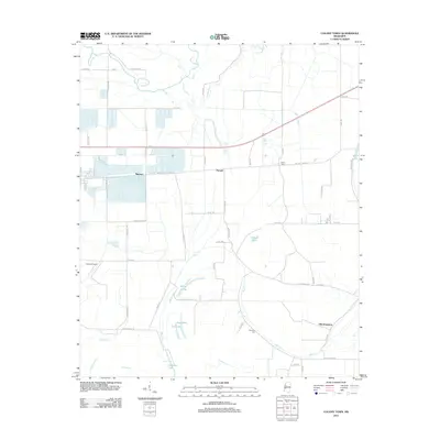
2012 Map of Colony Town
USGS Topo · Published 2012About this map
The alluvial plains of Sunflower County are defined by a complex network of bayous and slow-moving waterways, where the Quiver River and Bear Cr snake through the landscape. This 2012 survey reveals a rural settlement pattern centered on the community of Colony Town and the neighboring agricultural hubs of Mattoon and Purnell. The presence of Old Dominion in the southeast suggests the enduring influence of plantation-era naming conventions on modern land use.
Find a feature on this map
56 named features on this map. Tap any name to fly to it.
Don’t see what you’re looking for? This feature index may not catch every label — zoom into the map to look around manually.
Map Details
Editions of this 2012 Colony Town Map
This is the sole edition of this map. No revisions or reprints were ever made.
Other maps of this area

1931 · Schlater
USGS Topo · 1:48,000

1934 · Cleveland
USGS Topo · 1:62,500

1934 · Schlater
USGS Topo · 1:62,500

1939 · Schlater
USGS Topo · 1:62,500

1940 · Baird
USGS Topo · 1:62,500

1940 · Cleveland
USGS Topo · 1:62,500

1953 · Greenwood
USGS Topo · 1:250,000

1956 · Greenwood
USGS Topo · 1:250,000

1961 · Mossy Lake
USGS Topo · 1:62,500
1961 · Schlater
USGS Topo · 1:62,500