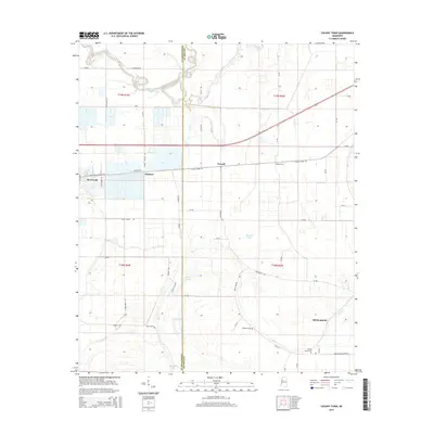
2015 Map of Colony Town
USGS Topo · Published 2015About this map
Moorhead and the surrounding Delta flatlands are defined by a complex network of waterways and early 21st-century agricultural infrastructure. The landscape is characterized by the winding path of the Quiver River in the north and the intricate drainage of Bear Creek and Gin Bayou across the eastern reaches. The survey captures the established settlements of Mattoon, Purnell, and Colony Town, alongside smaller named points like Old Dominion. This region in Sunflower and Leflore Counties shows a grid of county roads such as Colony Town Rd and Trans Fishery Rd that provide access to isolated wetlands and lakes, including McCoy Lake, Jug Lake, and the cypress-lined Cordy Brake. For local historians, the placement of Robinson Cem and Mount Home Cem provides essential grounding for family research in this rural Mississippi landscape.
Find a feature on this map
60 named features on this map. Tap any name to fly to it.
Don’t see what you’re looking for? This feature index may not catch every label — zoom into the map to look around manually.
Map Details
Editions of this 2015 Colony Town Map
This is the sole edition of this map. No revisions or reprints were ever made.
Other maps of this area

1931 · Schlater
USGS Topo · 1:48,000

1934 · Cleveland
USGS Topo · 1:62,500

1934 · Schlater
USGS Topo · 1:62,500

1939 · Schlater
USGS Topo · 1:62,500

1940 · Baird
USGS Topo · 1:62,500

1940 · Cleveland
USGS Topo · 1:62,500

1953 · Greenwood
USGS Topo · 1:250,000

1956 · Greenwood
USGS Topo · 1:250,000

1961 · Mossy Lake
USGS Topo · 1:62,500
1961 · Schlater
USGS Topo · 1:62,500