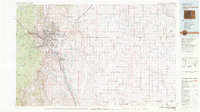
1981 Map of Colorado Springs
USGS Topo · Published 1981About this map
Fort Carson Military Reservation and the Air Force Academy anchor the western portion of this 1981 survey, illustrating the significant military presence surrounding Colorado Springs. The urban corridor follows Fountain Creek southward through the communities of Security and Widefield toward Fountain, while the Rampart Range rises sharply to the west within the Pike National Forest. Notable peaks such as Cheyenne Mountain and St Peters Dome dominate the skyline above Manitou Springs, where the famous Manitou and Pikes Peak (Cog RR) begins its ascent.
Find a feature on this map
75 named features on this map. Tap any name to fly to it.
Don’t see what you’re looking for? This feature index may not catch every label — zoom into the map to look around manually.
Map Details
Editions of this 1981 Colorado Springs Map
2 editions found
Other maps of this area

1889 · Canon City
USGS Topo · 1:125,000

1889 · Sanborn
USGS Topo · 1:125,000

1891 · Sanborn
USGS Topo · 1:125,000

1891 · Catlin
USGS Topo · 1:125,000

1891 · Pueblo
USGS Topo · 1:125,000

1891 · Nepesta
USGS Topo · 1:125,000

1891 · Limon
USGS Topo · 1:125,000

1892 · Limon
USGS Topo · 1:125,000

1892 · Canon City
USGS Topo · 1:125,000

1893 · Nepesta
USGS Topo · 1:125,000