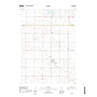
2017 Map of Colton
USGS Topo · Published 2017About this map
The Coteau des Prairies highland region of South Dakota serves as the backdrop for this rural survey, where the settlement of Colton anchors a landscape of agricultural sections and scattered water bodies. The terrain is characterized by numerous glacial features, including Buffalo Slough, Spring Lake, and Anderson Slough, which drain toward Colton Cr and Skunk Cr. For genealogists and local historians, the area is notably dense with small cemeteries that reflect early parish life, such as Zion Lutheran Cem, Bethania Cem, and Saint Joseph Cem. The map documents the grid-like progression of township roads and county highways like Co HWY 104 that define the border between Lake, Moody, and Minnehaha counties, providing a precise look at the rural infrastructure and the small community of Huntimer north of the main town site.
Find a feature on this map
61 named features on this map. Tap any name to fly to it.
Don’t see what you’re looking for? This feature index may not catch every label — zoom into the map to look around manually.
Map Details
Editions of this 2017 Colton Map
This is the sole edition of this map. No revisions or reprints were ever made.
Other maps of this area

1955 · Sioux Falls
USGS Topo · 1:250,000

1958 · Sioux Falls
USGS Topo · 1:250,000

1962 · Colton SE
USGS Topo · 1:24,000

1962 · Hartford North
USGS Topo · 1:24,000

1962 · Crooks
USGS Topo · 1:24,000

1963 · Colman
USGS Topo · 1:24,000

1964 · Humboldt
USGS Topo · 1:24,000

1968 · Lake Madison
USGS Topo · 1:24,000

1968 · Wentworth
USGS Topo · 1:24,000
1968 · Colton
USGS Topo · 1:24,000