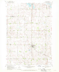
1968 Map of Colton
USGS Topo · Published 1970About this map
Colton serves as the primary hub on this South Dakota prairie landscape, situated near the intersection of several township boundaries including Taopi, Burk, and Grand Meadow. The map reveals a high concentration of rural burial sites, such as Huntimer Cem and St Ansgar Cem, which reflect the early settlement patterns of the late 19th and early 20th centuries. Transportation and utility infrastructure are prominent, with the Great Northern Railroad Grade and a cross-country pipeline cutting across the agricultural grid.
Find a feature on this map
25 named features on this map. Tap any name to fly to it.
Don’t see what you’re looking for? This feature index may not catch every label — zoom into the map to look around manually.
Map Details
Editions of this 1968 Colton Map
This is the sole edition of this map. No revisions or reprints were ever made.
Other maps of this area

1955 · Sioux Falls
USGS Topo · 1:250,000

1958 · Sioux Falls
USGS Topo · 1:250,000

1962 · Colton SE
USGS Topo · 1:24,000

1962 · Hartford North
USGS Topo · 1:24,000

1962 · Crooks
USGS Topo · 1:24,000

1963 · Colman
USGS Topo · 1:24,000

1964 · Humboldt
USGS Topo · 1:24,000

1968 · Lake Madison
USGS Topo · 1:24,000

1968 · Wentworth
USGS Topo · 1:24,000
1968 · Buffalo Trading Post
USGS Topo · 1:24,000