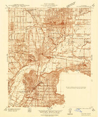
1938 Map of Colton
USGS Topo · Published 1938About this map
Industrial and transit networks define this pre-war survey of the Inland Empire, where the Colton hub serves as a major intersection for the Southern Pacific, Pacific Electric, and Atchison Topeka and Santa Fe Railway. The landscape is a mix of agricultural processing and heavy industry, evidenced by the Icing Plant in San Bernardino and the large Cement Plant at the base of Slover Mtn.
Find a feature on this map
69 named features on this map. Tap any name to fly to it.
Don’t see what you’re looking for? This feature index may not catch every label — zoom into the map to look around manually.
Map Details
Editions of this 1938 Colton Map
This is the sole edition of this map. No revisions or reprints were ever made.
Other maps of this area

1896 · San Bernardino
USGS Topo · 1:62,500

1898 · San Bernardino
USGS Topo · 1:62,500

1899 · Redlands
USGS Topo · 1:62,500

1901 · Southern California Sheet No. 1
USGS Topo · 1:250,000

1901 · San Bernardino
USGS Topo · 1:62,500

1901 · Redlands
USGS Topo · 1:62,500

1901 · Elsinore
USGS Topo · 1:125,000

1901 · Riverside
USGS Topo · 1:62,500

1904 · Southern California Sheet No. 1
USGS Topo · 1:250,000

1936 · Devore
USGS Topo · 1:31,680