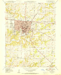
1950 Map of Columbia
USGS Topo · Published 1950About this map
The University of Missouri campus anchors this mid-century view of the region, showing the academic core and Memorial Stadium before the major expansions of the later 20th century. Adjacent to the university, Christian College and Stephens College establish the town's character as an educational center. Beyond the city grid, the landscape transitions into a network of small rural institutions and resource extraction sites, including numerous schools like Keene Sch and Grindstone Sch, along with several Inactive Mine locations and Brick Kilns to the east. The Wabash RR and Fulton Road serve as primary transportation arteries, while the southern reaches remain largely agricultural, defined by the winding paths of Hinkson Creek and Grindstone Creek and dotted with local landmarks such as Sugar Grove Ch and the Home for the Aged.
Find a feature on this map
58 named features on this map. Tap any name to fly to it.
Don’t see what you’re looking for? This feature index may not catch every label — zoom into the map to look around manually.
Map Details
Editions of this 1950 Columbia Map
2 editions found
Other maps of this area

1886 · Jefferson City
USGS Topo · 1:125,000

1890 · Moberly
USGS Topo · 1:125,000

1894 · Jefferson City
USGS Topo · 1:125,000

1917 · Sturgeon
USGS Topo · 1:62,500

1935 · Columbia
USGS Topo · 1:24,000

1940 · Columbia
USGS Topo · 1:24,000

1944 · Millersburg
USGS Topo · 1:62,500

1945 · Centralia
USGS Topo · 1:62,500

1946 · Millersburg
USGS Topo · 1:62,500

1947 · Jefferson City
USGS Topo · 1:250,000