
1953 Map of Columbia East
USGS Topo · Published 1956About this map
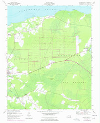
Albemarle Sound forms the northern boundary of this Tyrrell County landscape, where the coastal plain meets a network of wetlands and small rural settlements in the mid-1950s. The northern shoreline is marked by early-century points like Ship Pt and Palmetto Pt, while inland, the terrain is dominated by the Big Savanna and the elevated Dillion Ridge. This era shows a community structured around small clusters like Soundside and Newfoundland, with local faith centers such as Missionary Ch, Freewill Ch, and Malachi Chapel serving as geographic anchors for genealogists. The topography reveals a complex drainage pattern where Riders Creek and Second Creek navigate the lowlands near Pleasant View. A notable Borrow Pit on the ridge suggests local infrastructure work, while the label for Cranberry Island indicates the unique wetland ecology of the Columbia and Alligator borderlands.
Find a feature on this map
23 named features on this map. Tap any name to fly to it.
Don’t see what you’re looking for? This feature index may not catch every label — zoom into the map to look around manually.
Map Details
Editions of this 1953 Columbia East Map
2 editions found
Other maps of this area

1906 · Hertford
USGS Topo · 1:62,500

1940 · Hertford
USGS Topo · 1:62,500

1940 · Wade Point
USGS Topo · 1:62,500

1943 · Wade Point
USGS Topo · 1:62,500

1943 · Columbia
USGS Topo · 1:125,000

1948 · Wade Point
USGS Topo · 1:62,500

1953 · Norfolk
USGS Topo · 1:250,000

1953 · Scotia
USGS Topo · 1:24,000

1953 · Columbia West
USGS Topo · 1:24,000

1953 · Frying Pan
USGS Topo · 1:24,000