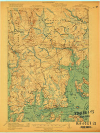
1921 Map of Columbia Falls
USGS Topo · Published 1921About this map
Maine Central Railroad tracks cut a horizontal line through this coastal landscape, connecting inland timber and granite resources to the sea. The surveyed area reveals a complex network of waterways, from the Machias River in the northeast to the Pleasant River in the west, defining the boundaries of maritime townships like Addison and Jonesport. These coastal communities are deeply integrated with the seafaring life of Englishman Bay and Moosabec Reach, where islands such as Roque Island and Great Wass Island shelter many harbors.
Find a feature on this map
86 named features on this map. Tap any name to fly to it.
Don’t see what you’re looking for? This feature index may not catch every label — zoom into the map to look around manually.
Map Details
Editions of this 1921 Columbia Falls Map
4 editions found
Other maps of this area

1902 · Cherryfield
USGS Topo · 1:62,500

1904 · Cherryfield
USGS Topo · 1:62,500

1904 · Petit Manan
USGS Topo · 1:62,500

1918 · Machias
USGS Topo · 1:62,500

1921 · Great Wass Island
USGS Topo · 1:62,500

1921 · Columbia Falls
USGS Topo · 1:62,500

1921 · Columbia Falls
USGS Topo · 1:62,500

1941 · Columbia Falls
USGS Topo · 1:62,500

1941 · Machias
USGS Topo · 1:62,500

1941 · Wesley
USGS Topo · 1:62,500