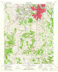
1965 Map of Columbia
USGS Topo · Published 1967About this map
The Duck River winds past the eastern edge of Columbia in this mid-1960s survey, documenting the city's mid-century expansion into suburban neighborhoods like Highland Park and West Meade. The map reveals a community defined by its civic and educational institutions, from the Carver-Smith High School and College Hill School to the Maury County Hospital. Traces of the local agrarian and industrial economy are evident in the numerous strip mines south of town and the reach of the Louisville and Nashville Railroad.
Find a feature on this map
112 named features on this map. Tap any name to fly to it.
Don’t see what you’re looking for? This feature index may not catch every label — zoom into the map to look around manually.
Map Details
Editions of this 1965 Columbia Map
4 editions found
Other maps of this area

1901 · Colombia
USGS Topo · 1:125,000

1936 · Godwin
USGS Topo · 1:24,000

1936 · Sandy Hook
USGS Topo · 1:24,000

1936 · Williamsport
USGS Topo · 1:24,000

1936 · Campbells Station
USGS Topo · 1:24,000

1936 · Carters Creek
USGS Topo · 1:24,000

1936 · Mount Pleasant
USGS Topo · 1:24,000

1936 · Glendale
USGS Topo · 1:24,000

1936 · Columbia
USGS Topo · 1:24,000

1936 · Lynnville
USGS Topo · 1:24,000