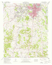
1965 Map of Columbia
USGS Topo · Published 1977About this map
The Duck River winds through the heart of Maury County, anchoring the regional center of Columbia. This mid-century survey reveals a city in transition, as residential expansions like Riverside, Fairview Heights, and Highland Park radiate from the core. Institutional landmarks of local significance are prominent, including the Columbia Military Academy and the Maury County Hospital. The map provides a detailed view of the area's educational landscape, showing segregated era vestiges through labels like Carver-Smith High School alongside Central High Sch.
Find a feature on this map
139 named features on this map. Tap any name to fly to it.
Don’t see what you’re looking for? This feature index may not catch every label — zoom into the map to look around manually.
Map Details
Editions of this 1965 Columbia Map
4 editions found
Other maps of this area

1901 · Colombia
USGS Topo · 1:125,000

1936 · Godwin
USGS Topo · 1:24,000

1936 · Sandy Hook
USGS Topo · 1:24,000

1936 · Williamsport
USGS Topo · 1:24,000

1936 · Campbells Station
USGS Topo · 1:24,000

1936 · Carters Creek
USGS Topo · 1:24,000

1936 · Mount Pleasant
USGS Topo · 1:24,000

1936 · Glendale
USGS Topo · 1:24,000

1936 · Columbia
USGS Topo · 1:24,000

1936 · Lynnville
USGS Topo · 1:24,000