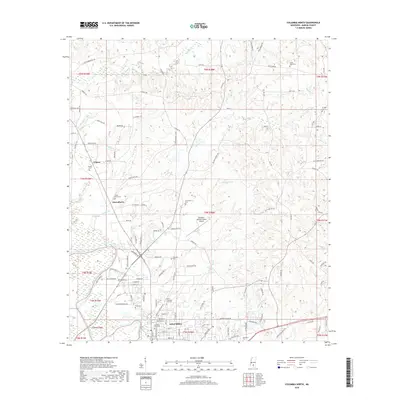
2018 Map of Columbia North
USGS Topo · Published 2018About this map
Columbia sits at the southern edge of this Marion County terrain, where the commercial center gives way to a landscape defined by the winding Pearl River and its numerous tributaries. The map details the transition from the city’s residential streets and the Columbia-Marion County Airport into the agricultural and wooded uplands to the north. Several small communities and family-named landmarks are scattered throughout the region, including Expose and Fortenberry. Genealogists will find a significant concentration of burial sites, ranging from the large Columbia City Cem and North Columbia City Cem to more rural locations such as Emmanuel Cem, Cedar Grove Cem, and Harmony Cem. A dense network of creeks, including Holiday Creek, Buckhorn Creek, and Balls Mill Creek, drains the rolling landscape toward the river valley, illustrating the historical importance of local water sources to the area's development.
Find a feature on this map
126 named features on this map. Tap any name to fly to it.
Don’t see what you’re looking for? This feature index may not catch every label — zoom into the map to look around manually.
Map Details
Editions of this 2018 Columbia North Map
This is the sole edition of this map. No revisions or reprints were ever made.
Other maps of this area

1953 · Hattiesburg
USGS Topo · 1:250,000

1958 · Hattiesburg
USGS Topo · 1:250,000

1969 · Pinebur
USGS Topo · 1:24,000

1970 · Columbia South
USGS Topo · 1:24,000

1970 · Sandy Hook NW
USGS Topo · 1:24,000

1970 · Bunker Hill
USGS Topo · 1:24,000

1970 · Morgantown
USGS Topo · 1:24,000

1970 · Oak Vale
USGS Topo · 1:24,000

1970 · Columbia North
USGS Topo · 1:24,000

1974 · Bassfield
USGS Topo · 1:24,000