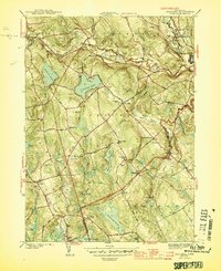
1944 Map of Columbia
USGS Topo · Published 1944About this map
Columbia and its surrounding hill country are defined by a complex network of glacial ponds and small-town infrastructure at the height of the Second World War. The landscape is interconnected by the New York New Haven and Hartford railroad, which follows the path of the Hop River and Willimantic River. Large water bodies like Columbia Lake and Andover Lake anchor the region, while smaller features such as Mono Pond and Williams Pond dot the terrain.
Find a feature on this map
64 named features on this map. Tap any name to fly to it.
Don’t see what you’re looking for? This feature index may not catch every label — zoom into the map to look around manually.
Map Details
Editions of this 1944 Columbia Map
3 editions found
Other maps of this area

1892 · Woodstock
USGS Topo · 1:62,500

1892 · Tolland
USGS Topo · 1:62,500

1892 · Norwich
USGS Topo · 1:62,500

1892 · Gilead
USGS Topo · 1:62,500

1921 · Tolland
USGS Topo · 1:62,500

1921 · Woodstock
USGS Topo · 1:62,500

1943 · Fitchville
USGS Topo · 1:31,680

1944 · Marlboro
USGS Topo · 1:31,680

1944 · South Coventry
USGS Topo · 1:31,680

1944 · Columbia
USGS Topo · 1:31,680