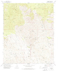
1969 Map of Columbia
USGS Topo · Published 1988About this map
Columbia stands at the center of this 1969 topographic study, situated along the Gila and Salt River Meridian in the high desert of the Bradshaw Mountains. The settlement pattern reflects a mid-century cattle and mining economy, where established landmarks like the Champie Ranch and the nearby Champie Sch served a sparse population of ranchers and prospectors. The landscape is heavily marked by small-scale mineral extraction, with named claims such as the Pero Bonito Mine, Lunan Mine, and Hardtimes Mine clustered along the drainages of Humbug Creek and Rockwall Gulch.
Find a feature on this map
68 named features on this map. Tap any name to fly to it.
Don’t see what you’re looking for? This feature index may not catch every label — zoom into the map to look around manually.
Map Details
Editions of this 1969 Columbia Map
4 editions found
Other maps of this area

1887 · Prescott
USGS Topo · 1:250,000

1892 · Prescott
USGS Topo · 1:250,000

1903 · Bradshaw Mountains
USGS Topo · 1:125,000

1947 · Crown King
USGS Topo · 1:62,500

1947 · Bumblebee
USGS Topo · 1:62,500

1948 · Bumblebee
USGS Topo · 1:63,360

1948 · Crown King
USGS Topo · 1:63,360

1950 · Crown King
USGS Topo · 1:62,500

1950 · Bumblebee
USGS Topo · 1:62,500

1950 · Prescott
USGS Topo · 1:250,000