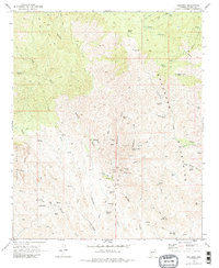
1969 Map of Columbia
USGS Topo · Published 1988About this map
Columbia sits at the heart of this late-1960s survey, surrounded by a high density of mining claims and desert settlements in Yavapai County. The landscape is defined by the sharp relief of the Bradshaw Mountains and the Gila and Salt River Meridian, where the economy of the era is etched into the terrain through numerous extraction sites. Gold-seekers and local historians can trace operations at the Red Star Mine, Lunan Mine, and Pero Bonito Mine, while the presence of the Cem and Champie Sch near Champie Ranch indicates a developed community structure. Notable historical sites like Fort Tule (Site) and infrastructure such as the Allen Mill Well provide a look at the region's development. The network of Humbug Creek and French Creek provides the primary drainage for this arid region, punctuated by seasonal water sources like Yellow Jacket Spring and Rockwall Spring.
Find a feature on this map
73 named features on this map. Tap any name to fly to it.
Don’t see what you’re looking for? This feature index may not catch every label — zoom into the map to look around manually.
Map Details
Editions of this 1969 Columbia Map
4 editions found
Other maps of this area

1887 · Prescott
USGS Topo · 1:250,000

1892 · Prescott
USGS Topo · 1:250,000

1903 · Bradshaw Mountains
USGS Topo · 1:125,000

1947 · Crown King
USGS Topo · 1:62,500

1947 · Bumblebee
USGS Topo · 1:62,500

1948 · Bumblebee
USGS Topo · 1:63,360

1948 · Crown King
USGS Topo · 1:63,360

1950 · Crown King
USGS Topo · 1:62,500

1950 · Bumblebee
USGS Topo · 1:62,500

1950 · Prescott
USGS Topo · 1:250,000