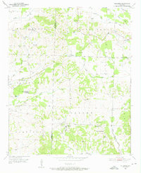
1951 Map of Columbus
USGS Topo · Published 1952About this map
Columbus serves as a central hub for this rural stretch of Hempstead County at the dawn of the 1950s, anchoring a landscape defined by its community institutions and the natural drainages of the Ozan Creek system. The map reveals a robust educational infrastructure, featuring both the Columbus High Sch and the County Training Sch near Corinth Ch. To the north, the small settlement of Buck Range sits near its namesake Buck Range Cem, while the central area is marked by Yancy and Temple Ch.
Find a feature on this map
33 named features on this map. Tap any name to fly to it.
Don’t see what you’re looking for? This feature index may not catch every label — zoom into the map to look around manually.
Map Details
Editions of this 1951 Columbus Map
3 editions found
Other maps of this area

1950 · Red Bluff
USGS Topo · 1:24,000

1951 · Red Bluff
USGS Topo · 1:24,000

1951 · Mineral Springs South
USGS Topo · 1:24,000

1951 · Columbus
USGS Topo · 1:24,000

1951 · Sheppard
USGS Topo · 1:24,000

1951 · Mineral Springs North
USGS Topo · 1:24,000

1951 · Nashville
USGS Topo · 1:24,000

1951 · Washington
USGS Topo · 1:24,000

1951 · Mc Nab
USGS Topo · 1:24,000

1951 · McCaskill
USGS Topo · 1:24,000