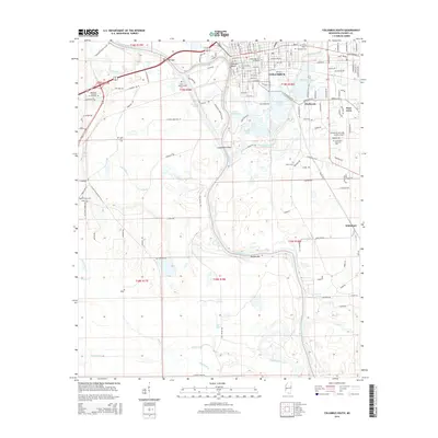
2015 Map of Columbus South
USGS Topo · Published 2015About this map
The Tombigbee River and Luxapalila Creek converge in this southern portion of Columbus, where the landscape transitions from the urban grid to the low-lying wetlands of the Black Prairie region. The historic campus of the Mississippi Univ for Women is a prominent fixture in the northern section of the map, situated near the industrial and commercial corridors of the city. The area is marked by numerous family and community landmarks, including Sandfield Cem and Saint Matthews Cem, which provide significant touchstones for local genealogy.
Find a feature on this map
146 named features on this map. Tap any name to fly to it.
Don’t see what you’re looking for? This feature index may not catch every label — zoom into the map to look around manually.
Map Details
Editions of this 2015 Columbus South Map
This is the sole edition of this map. No revisions or reprints were ever made.
Other maps of this area

1953 · West Point
USGS Topo · 1:250,000

1958 · West Point
USGS Topo · 1:250,000

1959 · Artesia
USGS Topo · 1:62,500

1959 · West Point
USGS Topo · 1:62,500

1960 · Caledonia
USGS Topo · 1:62,500

1960 · Columbus
USGS Topo · 1:62,500

1963 · West Point
USGS Topo · 1:250,000

1982 · West Point
USGS Topo · 1:100,000

1984 · West Point
USGS Topo · 1:250,000
1987 · Columbus North
USGS Topo · 1:24,000