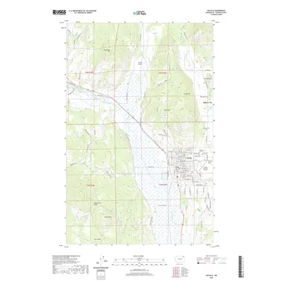
2020 Map of Colville
USGS Topo · Published 2020About this map
Colville sits at the heart of this Washington survey, serving as the primary hub within the broad Colville Valley. The map documents a town structured by a dense grid of streets such as E Astor Ave and E Birch Ave, positioned where the Colville River meets several mountain drainages. Just to the northeast, the site of Pinkney City and Garrison Flat point to the area's early settlement history. The landscape is defined by the sharp transition from the valley floor to the prominent heights of Colville Mtn, Eagle Peak, and the western edge of the Huckleberry Range. Local infrastructure and community markers are well-represented, from the Colville Municipal Airport on the eastern outskirts to a cluster of historic grounds including Evergreen Cem, Highland Cem, and Calvary Cem. Rural routes like Old Abandoned Hwy and Webley Mill Rd thread through the foothills, connecting the valley to the higher elevations of Rattlesnake Mtn and Paradis Peak.
Find a feature on this map
105 named features on this map. Tap any name to fly to it.
Don’t see what you’re looking for? This feature index may not catch every label — zoom into the map to look around manually.
Map Details
Editions of this 2020 Colville Map
This is the sole edition of this map. No revisions or reprints were ever made.
Other maps of this area

1927 · Chewelah
USGS Topo · 1:125,000

1929 · Colville
USGS Topo · 1:125,000

1930 · Chewelah
USGS Topo · 1:125,000

1933 · Colville
USGS Topo · 1:125,000

1936 · Marcus
USGS Topo · 1:96,000

1942 · Marcus
USGS Topo · 1:125,000

1948 · Kettle Falls
USGS Topo · 1:62,500

1950 · Inchelium
USGS Topo · 1:62,500

1951 · Kettle Falls
USGS Topo · 1:62,500

1952 · Gillette Mtn
USGS Topo · 1:24,000