
1929 Map of Colville
USGS Topo · Published 1958About this map
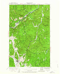
Colville sits as the hub of a landscape defined by intensive resource extraction and frontier transit in the late 1920s. The Northern Great Railway tracks follow the Columbia River and its tributaries, connecting mining outposts like Northport and Marble to the broader regional economy. This era represents a peak of industrial variety in Stevens County, where the map documents an incredible density of named mining operations, from the Electric Point Mine and Gladstone Mine in the north to the Old Dominion Mine further south.
Find a feature on this map
100 named features on this map. Tap any name to fly to it.
Don’t see what you’re looking for? This feature index may not catch every label — zoom into the map to look around manually.
Map Details
Editions of this 1929 Colville Map
2 editions found
Other maps of this area

1927 · Chewelah
USGS Topo · 1:125,000

1930 · Chewelah
USGS Topo · 1:125,000

1933 · Colville
USGS Topo · 1:125,000

1934 · Metaline
USGS Topo · 1:125,000

1936 · Marcus
USGS Topo · 1:96,000

1936 · Newport
USGS Topo · 1:96,000

1942 · Marcus
USGS Topo · 1:125,000

1942 · Metaline
USGS Topo · 1:125,000

1942 · Newport
USGS Topo · 1:125,000

1948 · Kettle Falls
USGS Topo · 1:62,500