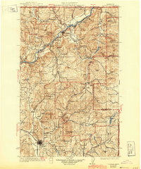
1933 Map of Colville
USGS Topo · Published 1943About this map
The Columbia River carves a deep path through northern Stevens County in this survey conducted between 1927 and 1929. The region’s economic foundation in the early twentieth century is clearly visible, anchored by the Great Northern railroad and an intensive network of mineral extraction sites. From the Old Dominion Mine near Colville to the Marble Quarry further north, the landscape is dotted with named pits and claims that drove local industry.
Find a feature on this map
134 named features on this map. Tap any name to fly to it.
Don’t see what you’re looking for? This feature index may not catch every label — zoom into the map to look around manually.
Map Details
Editions of this 1933 Colville Map
2 editions found
Other maps of this area

1927 · Chewelah
USGS Topo · 1:125,000

1929 · Colville
USGS Topo · 1:125,000

1930 · Chewelah
USGS Topo · 1:125,000

1933 · Colville
USGS Topo · 1:125,000

1934 · Metaline
USGS Topo · 1:125,000

1936 · Marcus
USGS Topo · 1:96,000

1936 · Newport
USGS Topo · 1:96,000

1942 · Marcus
USGS Topo · 1:125,000

1942 · Metaline
USGS Topo · 1:125,000

1942 · Newport
USGS Topo · 1:125,000