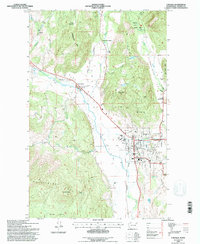
1992 Map of Colville
USGS Topo · Published 1996About this map
The Colville Valley serves as the focal point for this 1990s-era topographic study, where the Colville River snakes through a fertile corridor flanked by the Huckleberry Range and Old Town Mtn. The city of Colville is mapped in significant detail, showing its grid from Main St to the Colville Airport, along with essential community infrastructure like the Courthouse, City Hall, and Mt Carmel Hosp. Evidence of earlier settlement is preserved at the Pinkney City (Site) and the Fort Colville Historical Mon, while the agricultural heritage of Stevens County is visible at the Colville Valley Grange. To the north, the landscape transitions into the hills around Rattlesnake Mtn, marked by the Phipps Homestead and the recreational grounds of Douglas Falls Grange Park near the cascades of Douglas Falls.
Find a feature on this map
57 named features on this map. Tap any name to fly to it.
Don’t see what you’re looking for? This feature index may not catch every label — zoom into the map to look around manually.
Map Details
Editions of this 1992 Colville Map
This is the sole edition of this map. No revisions or reprints were ever made.
Other maps of this area

1927 · Chewelah
USGS Topo · 1:125,000

1929 · Colville
USGS Topo · 1:125,000

1930 · Chewelah
USGS Topo · 1:125,000

1933 · Colville
USGS Topo · 1:125,000

1936 · Marcus
USGS Topo · 1:96,000

1942 · Marcus
USGS Topo · 1:125,000

1948 · Kettle Falls
USGS Topo · 1:62,500

1950 · Inchelium
USGS Topo · 1:62,500

1951 · Kettle Falls
USGS Topo · 1:62,500

1952 · Gillette Mtn
USGS Topo · 1:24,000