
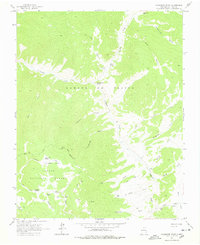
1963 Map of Comanche Point
USGS Topo · Published 1967About this map
Sangre de Cristo mountains dominate this 1963 landscape within the Carson National Forest, showcasing a high-altitude wilderness defined by deep drainage systems like Fernandez Canyon and Powderhouse Canyon. Evidence of old-line resource extraction and mountain hospitality is scattered throughout the drainages, notably at the Midnight Mine and Anchor Mine near Bitter Creek. These mining sites sit south of the prominent Comanche Point, which overlooks the winding course of Costilla Creek.
Find a feature on this map
35 named features on this map. Tap any name to fly to it.
Don’t see what you’re looking for? This feature index may not catch every label — zoom into the map to look around manually.
Map Details
Editions of this 1963 Comanche Point Map
2 editions found
Other maps of this area

1954 · Raton
USGS Topo · 1:250,000

1955 · Ute Park
USGS Topo · 1:62,500

1958 · Raton
USGS Topo · 1:250,000

1962 · Ash Mountain
USGS Topo · 1:62,500

1963 · Amalia
USGS Topo · 1:24,000

1963 · Red River Pass
USGS Topo · 1:24,000

1963 · Latir Peak
USGS Topo · 1:24,000

1963 · Red River
USGS Topo · 1:24,000

1963 · Big Costilla Peak
USGS Topo · 1:24,000

1982 · Wheeler Peak
USGS Topo · 1:100,000