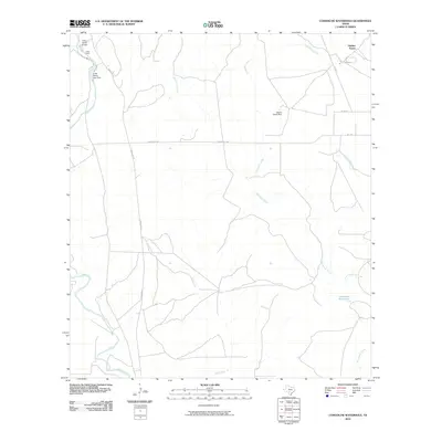
2010 Map of Comanche Waterhole
USGS Topo · Published 2010About this map
Comanche Waterhole serves as the namesake for this central Texas landscape, where the drainage networks of the Edwards Plateau converge before reaching the coastal plains. Large agricultural and ranching operations define the local geography, notably the sprawling Valdina Farms and K Bar Ranch. Water management is central to the area's utility, evidenced by the Valdina Farms Dam and K-Bar Ranch Lake Dam, which regulate the intermittent flow of Comanche Creek and the Sabinal River. These waterways, along with Rancheros Creek and Elm Creek, create a complex hydrologic pattern through the brush country. Infrastructure is largely focused on ranching needs, including the private K Bar Ranch Airport and a network of secondary roads such as Ranch Rd 1796 and FM 1796.
Find a feature on this map
18 named features on this map. Tap any name to fly to it.
Don’t see what you’re looking for? This feature index may not catch every label — zoom into the map to look around manually.
Map Details
Editions of this 2010 Comanche Waterhole Map
This is the sole edition of this map. No revisions or reprints were ever made.
Other maps of this area

1898 · Uvalde
USGS Topo · 1:125,000

1899 · Uvalde
USGS Topo · 1:125,000

1954 · San Antonio
USGS Topo · 1:250,000

1956 · Sabinal
USGS Topo · 1:62,500

1956 · Tarpley
USGS Topo · 1:62,500

1956 · Utopia
USGS Topo · 1:62,500

1957 · San Antonio
USGS Topo · 1:250,000
1969 · Texas Mountain
USGS Topo · 1:24,000

1969 · Sabinal NE
USGS Topo · 1:24,000

1969 · Comanche Waterhole
USGS Topo · 1:24,000