
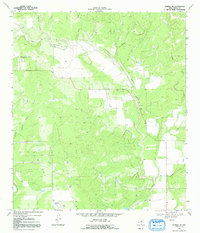
1969 Map of Sabinal NE
USGS Topo · Published 1972About this map
The hills and drainage basins of western Medina County define this 1969 landscape, where ranching and early industrial development intersect. The Seco Valley serves as a central corridor for Seco Creek, which is fed by numerous tributaries including Rocky Creek and Parkers Creek. A notable presence in the southwest is the Automotive Test Facility, characterized by its distinct circular track, indicating the region's role in industrial proving grounds during the late 1960s.
Find a feature on this map
10 named features on this map. Tap any name to fly to it.
Don’t see what you’re looking for? This feature index may not catch every label — zoom into the map to look around manually.
Map Details
Editions of this 1969 Sabinal NE Map
2 editions found
Other maps of this area

1954 · San Antonio
USGS Topo · 1:250,000

1956 · Sabinal
USGS Topo · 1:62,500

1956 · New Fountain
USGS Topo · 1:62,500

1956 · Tarpley
USGS Topo · 1:62,500

1956 · Bandera
USGS Topo · 1:62,500

1957 · San Antonio
USGS Topo · 1:250,000
1969 · Twin Hollow
USGS Topo · 1:24,000
1969 · Texas Mountain
USGS Topo · 1:24,000

1969 · Comanche Waterhole
USGS Topo · 1:24,000
1969 · Flatrock Crossing
USGS Topo · 1:24,000