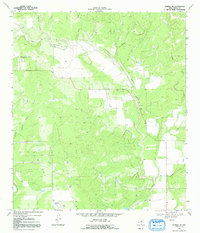
1969 Map of Sabinal NE
USGS Topo · Published 1992About this map
Seco Valley defines the landscape of this Medina County quadrangle, where the drainages of Seco Creek and Parkers Creek cut through the South Texas brush country. The map captures a transition toward specialized land use during the late 1960s, most notably with the sprawling Automotive Test Facility located in the western sector. This industrial footprint, complete with its own Landing Field, stands in contrast to the traditional ranching landscape marked by numerous Wells and drainage systems like Cedar Creek and Rocky Creek. The presence of a Gravel Pit along the eastern bluffs suggests local resource extraction, while the intermittent nature of Comanche Creek and Live Oak Cr reflects the arid character of the region. This survey serves as a detailed record of how mid-century engineering and large-scale testing grounds began to reshape these rural Texas creek valleys.
Find a feature on this map
12 named features on this map. Tap any name to fly to it.
Don’t see what you’re looking for? This feature index may not catch every label — zoom into the map to look around manually.
Map Details
Editions of this 1969 Sabinal NE Map
2 editions found
Other maps of this area

1954 · San Antonio
USGS Topo · 1:250,000

1956 · Sabinal
USGS Topo · 1:62,500

1956 · New Fountain
USGS Topo · 1:62,500

1956 · Tarpley
USGS Topo · 1:62,500

1956 · Bandera
USGS Topo · 1:62,500

1957 · San Antonio
USGS Topo · 1:250,000
1969 · Twin Hollow
USGS Topo · 1:24,000
1969 · Texas Mountain
USGS Topo · 1:24,000

1969 · Sabinal NE
USGS Topo · 1:24,000

1969 · Comanche Waterhole
USGS Topo · 1:24,000