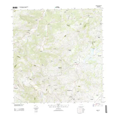
2013 Map of Comerio
USGS Topo · Published 2013About this map
Comerío and Cidra anchor this 2013 survey of the mountainous interior of the Island of Puerto Rico. The landscape is defined by the winding course of the Río de la Plata, which carves deep valleys through the Cordillera Central, joined by numerous tributaries such as Quebrada Anones and Quebrada Higuera. Residential patterns are captured in the clusterings of Parcelas La Milagrosa and Parcelas Nuevas, reflecting the unique rural-to-urban development of the region's barrios. The high elevation is marked by peaks like Cerro La Tiza and Cerro Viento Caliente, while the eastern portion of the map is dominated by the waters of Lago de Cidra. The network of roads, including Calle La Charca and Avenida El Jibaro, highlights the connectivity between isolated mountain settlements and the larger municipal centers of Cayey and Aibonito.
Find a feature on this map
83 named features on this map. Tap any name to fly to it.
Don’t see what you’re looking for? This feature index may not catch every label — zoom into the map to look around manually.
Map Details
Editions of this 2013 Comerio Map
This is the sole edition of this map. No revisions or reprints were ever made.
Other maps of this area

1946 · Patillas
USGS Topo · 1:30,000

1946 · Coamo
USGS Topo · 1:30,000

1946 · Aguas Buenas
USGS Topo · 1:30,000

1946 · Corozal
USGS Topo · 1:30,000

1946 · Barranquitas
USGS Topo · 1:30,000

1946 · Cayey
USGS Topo · 1:30,000

1946 · Comerio
USGS Topo · 1:30,000

1946 · Naranjito
USGS Topo · 1:30,000

1946 · Caguas
USGS Topo · 1:30,000

1947 · Cayey NO
USGS Topo · 1:10,000
Featured Places
- Cidra
- Comerío
- Sector Delfín "Fito" Cartagena Hernández, Aguas Buenas
- Comunidad La Cumbre, Cidra
- Comunidad Concepción, Cidra