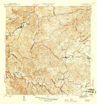
1946 Map of Comerio
USGS Topo · Published 1946About this map
Río La Plata carves a winding path through this mid-1940s landscape, connecting the urban center of Comerío with the highland basin surrounding Cidra. The survey, published by the Government of Puerto Rico and the U.S. Geological Survey, illustrates a transition in rural education and social infrastructure. Multiple educational sites, including the Escuela Superior de Comerío and several rural second units like Escuela Segunda Unidad de Toíta, are distributed along the ridges and valleys. The presence of the Proyecto La Plata and the Centro Comunal Nogueras suggests the era's focus on rural development and community organization. Across the southern portion of the sheet, the influence of the sugar industry is marked by the presence of Central Cayey. The map reveals a densely named network of tributaries, such as Quebrada Doña Elena and Quebrada Usabón, which defined the boundaries of numerous municipios.
Find a feature on this map
51 named features on this map. Tap any name to fly to it.
Don’t see what you’re looking for? This feature index may not catch every label — zoom into the map to look around manually.
Map Details
Editions of this 1946 Comerio Map
3 editions found
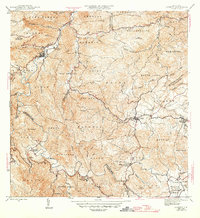
Other maps of this area

1946 · Patillas
USGS Topo · 1:30,000

1946 · Coamo
USGS Topo · 1:30,000

1946 · Aguas Buenas
USGS Topo · 1:30,000

1946 · Corozal
USGS Topo · 1:30,000

1946 · Barranquitas
USGS Topo · 1:30,000

1946 · Cayey
USGS Topo · 1:30,000

1946 · Comerio
USGS Topo · 1:30,000

1946 · Naranjito
USGS Topo · 1:30,000

1946 · Caguas
USGS Topo · 1:30,000

1947 · Cayey NO
USGS Topo · 1:10,000