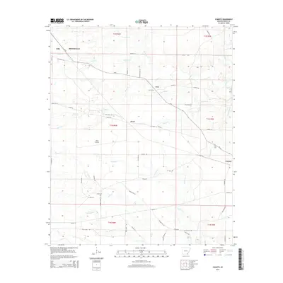
2014 Map of Cominto
USGS Topo · Published 2014About this map
Wolf Prairie and the surrounding drainage basins of the Hurricane Cr and Sandy Cr systems define this corner of Drew County. Small settlements such as Enon, Deane, and Cominto are linked by a network of local routes including Ar-35 and Old Dermott RD. The map reveals a rural landscape deeply tied to its watercourses, with Tucker Cr and Rainbow Cr carving through the terrain. Genealogists will find significant local history at the Enon Cem, Rash Cem, and Moore Cem, which serve as quiet markers of the community's ancestral footprint. The transition from the more developed area of Monticello in the northwest to the open expanses of the prairie illustrates the shifting land use in this part of southeastern Arkansas during the early 21st century.
Find a feature on this map
66 named features on this map. Tap any name to fly to it.
Don’t see what you’re looking for? This feature index may not catch every label — zoom into the map to look around manually.
Map Details
Editions of this 2014 Cominto Map
This is the sole edition of this map. No revisions or reprints were ever made.
Other maps of this area

1935 · Mist
USGS Topo · 1:62,500

1935 · Cominto
USGS Topo · 1:62,500

1953 · Greenwood
USGS Topo · 1:250,000

1956 · Greenwood
USGS Topo · 1:250,000

1960 · Mist
USGS Topo · 1:62,500

1960 · Selma
USGS Topo · 1:24,000

1960 · Collins NW
USGS Topo · 1:24,000

1960 · Collins
USGS Topo · 1:24,000

1960 · Collins
USGS Topo · 1:62,500
1960 · Line
USGS Topo · 1:24,000