
1960 Map of Selma
USGS Topo · Published 1961About this map
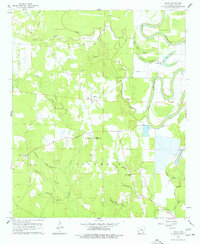
Selma sits at the heart of this 1960 survey, serving as a focal point for a community defined by its watercourses and small-scale infrastructure. The landscape is heavily influenced by the meandering Bayou Bartholomew on the eastern edge, which creates a series of wetlands including Middle Track Brake, Trotters Brake, and Horseshoe Brake. These backwater features, combined with numerous creek systems like Cutoff Creek and Ables Creek, illustrate the complex drainage of the Drew County delta region during this period.
Find a feature on this map
31 named features on this map. Tap any name to fly to it.
Don’t see what you’re looking for? This feature index may not catch every label — zoom into the map to look around manually.
Map Details
Editions of this 1960 Selma Map
2 editions found
Other maps of this area

1935 · Cominto
USGS Topo · 1:62,500

1935 · Rotan
USGS Topo · 1:62,500

1935 · Red Fork
USGS Topo · 1:62,500

1936 · McGehee
USGS Topo · 1:62,500

1937 · McGehee
USGS Topo · 1:62,500

1953 · Greenwood
USGS Topo · 1:250,000

1955 · McGehee
USGS Topo · 1:62,500

1956 · Greenwood
USGS Topo · 1:250,000

1960 · Collins NW
USGS Topo · 1:24,000

1960 · Collins
USGS Topo · 1:24,000