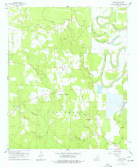
1960 Map of Selma
USGS Topo · Published 1977About this map
Selma sits at the center of this rural Arkansas landscape, serving as a focal point for the surrounding Live Oak and Franklin townships. The area is defined by the winding course of Bayou Bartholomew to the east, whose meandering path created distinctive wetlands and oxbows like Mink Track Brake and Horseshoe Brake. This 1960 survey illustrates a community deeply rooted in its local institutions, featuring the Selma Jr High Sch and a network of country churches including Sweet Hope Ch and Oak Grove Ch.
Find a feature on this map
32 named features on this map. Tap any name to fly to it.
Don’t see what you’re looking for? This feature index may not catch every label — zoom into the map to look around manually.
Map Details
Editions of this 1960 Selma Map
2 editions found
Other maps of this area

1935 · Cominto
USGS Topo · 1:62,500

1935 · Rotan
USGS Topo · 1:62,500

1935 · Red Fork
USGS Topo · 1:62,500

1936 · McGehee
USGS Topo · 1:62,500

1937 · McGehee
USGS Topo · 1:62,500

1953 · Greenwood
USGS Topo · 1:250,000

1955 · McGehee
USGS Topo · 1:62,500

1956 · Greenwood
USGS Topo · 1:250,000

1960 · Selma
USGS Topo · 1:24,000

1960 · Collins NW
USGS Topo · 1:24,000