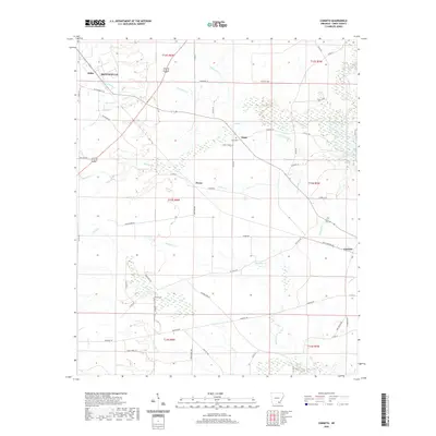
2020 Map of Cominto
USGS Topo · Published 2020About this map
Monticello anchors the northwest corner of this Drew County landscape, where the town's expansion meets the rural drainages of Adcock Creek and Hurricane Creek. The area is defined by a dense network of winding local roads and trails such as Dead Horse Trail and Kickton Trail, which weave through the timbered bottoms of the Sandy Creek and Wolf Creek systems. These watercourses create a distinct dendritic pattern across the terrain, shaping the development of smaller agricultural clusters like Enon, Deane, and Cominto. Genealogy researchers will find several well-preserved rural burial sites located near these early settlements, including Enon Cemetery and Rash Cemetery, providing a detailed look at the settlement patterns that persist in this part of Arkansas.
Find a feature on this map
50 named features on this map. Tap any name to fly to it.
Don’t see what you’re looking for? This feature index may not catch every label — zoom into the map to look around manually.
Map Details
Editions of this 2020 Cominto Map
This is the sole edition of this map. No revisions or reprints were ever made.
Other maps of this area

1935 · Mist
USGS Topo · 1:62,500

1935 · Cominto
USGS Topo · 1:62,500

1953 · Greenwood
USGS Topo · 1:250,000

1956 · Greenwood
USGS Topo · 1:250,000

1960 · Mist
USGS Topo · 1:62,500

1960 · Selma
USGS Topo · 1:24,000

1960 · Collins NW
USGS Topo · 1:24,000

1960 · Collins
USGS Topo · 1:24,000

1960 · Collins
USGS Topo · 1:62,500
1960 · Line
USGS Topo · 1:24,000