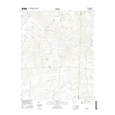
2016 Map of Como
USGS Topo · Published 2016About this map
The Middle Fork Obion River and its numerous tributaries shape the landscape of this rural corridor along the border of Weakley and Henry Counties. The small settlements of Ore Springs, Jewell, and Como serve as historical anchors for a region defined by family-named landmarks and water-control reservoirs. The map reveals an intricate network of small lakes and ponds, including Garrett Lake, Cypress Creek Lake Number Six, and several numbered reservoirs along Thompson Creek, illustrating modern hydrological management across the traditional farming terrain.
Find a feature on this map
99 named features on this map. Tap any name to fly to it.
Don’t see what you’re looking for? This feature index may not catch every label — zoom into the map to look around manually.
Map Details
Editions of this 2016 Como Map
This is the sole edition of this map. No revisions or reprints were ever made.
Other maps of this area

1936 · Crossland
USGS Topo · 1:24,000

1950 · Osage
USGS Topo · 1:24,000

1950 · Cottage Grove
USGS Topo · 1:24,000

1952 · Dresden
USGS Topo · 1:24,000

1955 · Henry
USGS Topo · 1:24,000

1956 · Latham
USGS Topo · 1:24,000
1956 · Palmersville
USGS Topo · 1:24,000

1956 · Dyersburg
USGS Topo · 1:250,000

1957 · Como
USGS Topo · 1:24,000

1967 · Pillowville
USGS Topo · 1:24,000