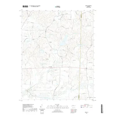
2019 Map of Como
USGS Topo · Published 2019About this map
Ore Springs and Jewell anchor this agricultural landscape in West Tennessee, where the Weakley and Henry county line divides the rural terrain. The map is notably dense with family and community burial grounds, such as Macks Grove Cem, Hickory Grove Cem, and Old Hickory Grove Cem, reflecting deep-rooted settlement patterns and genealogical heritage. Water management is a defining characteristic of the area, evidenced by a series of numbered reservoirs along Thompson Creek, including Thompson Cr Number Eight Lake and Thompson Cr Number Two Lake. To the south, the terrain descends toward the bottomlands of the Middle Fork Obion River, fed by numerous tributaries like Tumbling Creek and Thompson Creek. This survey captures the rural persistence of small crossroads communities and the importance of localized water resources in the region.
Find a feature on this map
104 named features on this map. Tap any name to fly to it.
Don’t see what you’re looking for? This feature index may not catch every label — zoom into the map to look around manually.
Map Details
Editions of this 2019 Como Map
This is the sole edition of this map. No revisions or reprints were ever made.
Other maps of this area

1936 · Crossland
USGS Topo · 1:24,000

1950 · Osage
USGS Topo · 1:24,000

1950 · Cottage Grove
USGS Topo · 1:24,000

1952 · Dresden
USGS Topo · 1:24,000

1955 · Henry
USGS Topo · 1:24,000

1956 · Latham
USGS Topo · 1:24,000
1956 · Palmersville
USGS Topo · 1:24,000

1956 · Dyersburg
USGS Topo · 1:250,000

1957 · Como
USGS Topo · 1:24,000

1967 · Pillowville
USGS Topo · 1:24,000