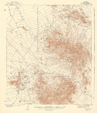
1942 Map of Comobabi
USGS Topo · Published 1942About this map
Picacho Mine and several other extraction sites anchor the southwestern foothills of the South Comobabi Mountains, reflecting the mineral prospecting that shaped this desert landscape before World War II. The map, based on a 1937 survey, documents the remote settlements and infrastructure within the Papago Indian Reservation, where water availability dictated the placement of small communities like Sil Nakya and Sand Wells. A sparse network of trails and unimproved roads connects these outposts across the Santa Rosa Valley to family-named landmarks such as Mt Devine. The presence of numerous Wells and small scattered settlements like Ko Vaya and Wickchoupai highlights the adaptation to the arid climate, while the cluster of Cooncan Mine and Mildren Mine suggests the localized intensity of early 20th-century mining activity.
Find a feature on this map
22 named features on this map. Tap any name to fly to it.
Don’t see what you’re looking for? This feature index may not catch every label — zoom into the map to look around manually.
Map Details
Editions of this 1942 Comobabi Map
2 editions found
Other maps of this area

1934 · Silver Bell
USGS Topo · 1:125,000

1937 · Comobabi
USGS Topo · 1:48,000

1938 · San Vicente
USGS Topo · 1:62,500

1941 · San Vicente
USGS Topo · 1:62,500

1941 · Baboquivari Peak
USGS Topo · 1:62,500

1941 · Sells
USGS Topo · 1:62,500

1942 · San Vicente
USGS Topo · 1:62,500

1942 · Comobabi
USGS Topo · 1:62,500

1943 · Sells
USGS Topo · 1:62,500

1943 · Fresnal
USGS Topo · 1:125,000