
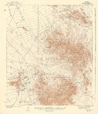
1942 Map of Comobabi
USGS Topo · Published 1942About this map
North Comobabi Mountains and the South Comobabi Mountains dominate this 1937 topographical survey, revealing the remote settlement patterns within the Papago Indian Reservation. The map records a landscape defined by isolated wells and mining operations, such as the Picacho Mine and Cooncan Mine, which were active or significant enough to be noted in the late 1930s. Small communities like Sil Nakya, Ko Vaya, and Santa Lucia are shown connected by primitive roads and trails that traverse the arid Santa Rosa Valley. This survey captures the region's reliance on groundwater, marking numerous dams and points like Sand Wells and Dry Well, which were critical for both local inhabitants and the small-scale mining industry that sought mineral wealth in the Nicki Hills and surrounding ranges.
Find a feature on this map
26 named features on this map. Tap any name to fly to it.
Don’t see what you’re looking for? This feature index may not catch every label — zoom into the map to look around manually.
Map Details
Editions of this 1942 Comobabi Map
2 editions found
Other maps of this area

1934 · Silver Bell
USGS Topo · 1:125,000

1937 · Comobabi
USGS Topo · 1:48,000

1938 · San Vicente
USGS Topo · 1:62,500

1941 · San Vicente
USGS Topo · 1:62,500

1941 · Baboquivari Peak
USGS Topo · 1:62,500

1941 · Sells
USGS Topo · 1:62,500

1942 · San Vicente
USGS Topo · 1:62,500

1943 · Sells
USGS Topo · 1:62,500

1943 · Fresnal
USGS Topo · 1:125,000

1944 · Baboquivari Peak
USGS Topo · 1:62,500